J2Ski Snow Report - September 18th 2025
J2Ski Snow Report - September 18th 2025
Published : 18-Sep-2025 06:48
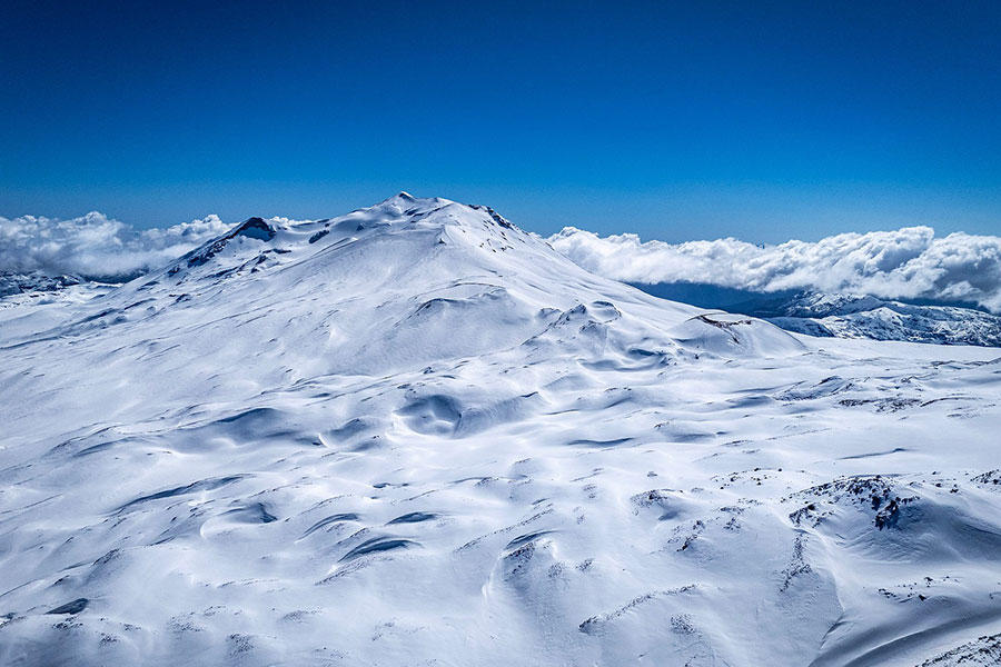
Nevados de Chillán, Chile, coming to the end of their season...
The changing of the seasons globally is evident, with fresh snowfall in the Colorado Rockies and ski areas in the Andes beginning to close. The Alps and Scandinavia are seeing the first openings of the new season, while Chile's Nevados de Chillan will close this weekend.
The Snow Headlines - September 18th
- First snowfalls in Colorado Rockies.
- Ski areas in the Andes begin closing - Chile's Nevados de Chillan this weekend.
- Scandinavia's ski season set to restart with glacier area due to reopen.
- Second Italian glacier area opening this weekend.
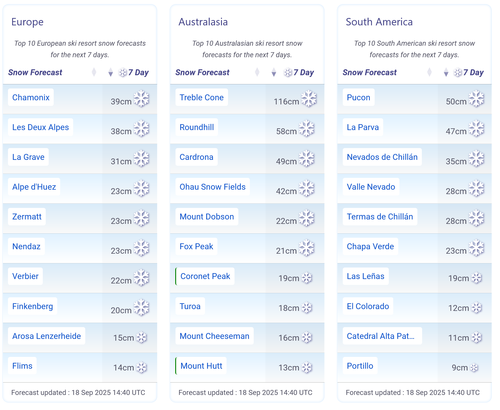
Autumn snow forecast for The Alps, and decent spring snow incoming for The Andes and New Zealand.
Re-publication :- the J2Ski Snow Report Summary, being the text above this line, is free to re-publish, but must be clearly credited to www.J2ski.com with text including "J2Ski Snow Report" linked to this page - thank you.
World Overview
There's a real sense of changing seasons around the world this weekend, as the start of full springtime in the southern hemisphere and full autumn/fall in the northern arrives with the astronomical change catching up with the meteorological one three weeks ago.
The change has seen months of hot weather turn to fresh snowfall up high in the Rockies, the first new resort openings in the Alps and Scandinavia for over a month and big name resorts in the southern hemisphere begin closing for the season this weekend.
Southern Hemisphere
Australia
Fresh snow added 10–20 cm/4 to 8 inches to Aussie slopes last week, but spring warmth is thinning snowpacks—especially lower down. Still, it remains one of the best seasons in years, with some of the world's deepest September bases and 3–5 cm/1 to 2 inches of fresh snow reported in the last few days.
Perisher leads the world with the most open terrain, while Thredbo and Charlotte Pass remain strong after 15 cm/6 inches of top-ups, with the latter currently posting the world's deepest snowpack at 2.3 m/7.5 feet.
Mount Hotham, Falls Creek, and Mount Buller offer great coverage, although lower slopes soften by midday. Tasmania's Ben Lomond and Mount Mawson are holding firm.
Light snow (2–12 cm/1 to 5 inches) is forecast, with the snow line dipping to 1100–1500 m/3609 to 4921 feet. So, it's mostly icy mornings, sticky afternoons, and classic late-season variety.
New Zealand
New Zealand's ski fields continue to post some of their best conditions of the season after a snowy September, with North Island centres Whakapapa and Tūroa expanding terrain and lift access as bases build.
Whakapapa's West Ridge Quad is reopening after two years, thanks to a major team effort.
Most South Island resorts are also in top form, with Mount Hutt leading on depth, while Porter Heights, Olympus, Craigieburn, Cardrona, Treble Cone, and The Remarkables report fresh cover this week.
Gale-force winds have caused occasional closures, but another wintry blast is due, with 10–39 cm/4 to 15 inches forecast over the coming week along with cold temperatures, gusty winds, and low visibility before clearer spells return.
Argentina
Argentina's ski season is winding down, with mostly dry, sunny weather and light snowfalls. Summit temperatures dip to –10°C/14°F overnight, rising to +3°C/37°F by day, while lower slopes reach +10°C/50°F—bringing classic spring freeze-thaw conditions.
Catedral Alta Patagonia has refreshed slightly, but open terrain remains limited.
Las Leñas leads on depth, though it is still not great, just over a metre/3 feet, offering powder-filled bowls. Cerro Castor boasts near-full lift access (the highest percentage open in the country) and packed powder. Generally, conditions are holding up, though afternoon softening is typical at this time of year, and two centres, Chapelco and Caviahue, ended their seasons last weekend.
Light to moderate snowfall is forecast, but with gusty winds, cloud cover, and variable visibility.
Chile
Chile's ski season is nearing its end, with mostly sunny skies and mild spring temperatures.
Summit highs have reached +5°C/41°F, but overnight freezes continue, creating firm morning pistes and softening snow by afternoon. Powder is scarce, but groomed runs remain in excellent shape.
Valle Nevado leads South America for snow depth (nearly 1.8 m/6 feet at the summit) and remains fully open, alongside neighbouring La Parva and El Colorado. Portillo has over 90% of its terrain open. Nevados de Chillán to the south is currently 100% open but will close on the 20th. A fresh snowfall is forecast which could bring up to 60 cm/24 inches of late-season snow for some.
Northern Hemisphere
The Alps
Alpine glacier areas are gearing up for the 2025/26 season, with Italy's Val Senales set to open this weekend and Austria's Pitztal and Sölden expected next week. Hintertux is also due to reopen soon.
Early snowfall has created ideal conditions for training at Val Senales (3,212 m/10,539 feet), with groomed trails for racers and a free-skiing zone for recreational skiers.
Glacier skiing at Saas-Fee and Zermatt remains open, offering firm morning snow and limited terrain.
Italy's Passo Stelvio is the third option right now and has reported powder conditions at times this past week after fresh snowfall.
Light snowfall continues above 2,500 m/8,200 feet, with freezing levels dropping to 2,600 m/8,530 feet.
Unsettled weather is forecast, with cloud cover, gusty winds, and occasional snow flurries above 3,000 m/9,843 feet—classic (very) early-season conditions as anticipation for the season ahead builds across the Alps.
Scandinavia
Lift-accessed skiing returns to Scandinavia this weekend as Norway's Galdhøpiggen Glacier reopens after a six-week summer closure. Early autumn conditions have helped preserve the snowpack, with light snowfall and overnight lows of –3°C/27°F.
Finland's Levi and Ruka are also preparing to open in early October, unveiling preserved snow, thanks to snow farming, from last season.
Galdhøpiggen has seen sleet, snow showers, and brisk winds midweek but patchy cloud and visibility improvements are expected by Saturday.
USA
Currently, there is nowhere open in North America, other than indoor snow at the Big Snow centre in New Jersey.
Temperatures have dropped across the Western USA, with overnight lows below freezing in high mountain zones like the Colorado Rockies. Daytime highs sit in the 60s–70s°F, with cooler air spreading into California and Oregon—classic early autumn conditions.
The Colorado Rockies saw their first snowfall at the weekend, with slightly more substantial falls midweek, and light snow remains possible at higher elevations.
A cold front will bring patchy snow to Utah, Montana, and the Pacific Northwest to end the week, but any accumulations will be modest, with clearer, calmer weather returning by the weekend.
Join the conversation : Discuss this in the J2Ski Forum
This news item has been viewed 87,633 times.
Also on J2Ski :- Sölden Snow Forecast Ski Hotels Ski Hire Ski Holidays